Mayan directional map
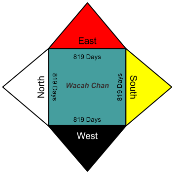
The four cardinal directions provided the fundamental grid for both the Maya communities and the surface of the earth. The most important direction was east which was associated with the color red. Maya cartographers would typically place east at the top of the page. North was associated with cool rains, and is represented by the color white. West is the dying place of the sun, represented by the color black. South was associated with the color yellow and was considered the right-hand of the sun.[1]
The four cardinal directions were seen in relationship to the center which was represented by the color blue-green. Running through this center, the Maya envisioned an axis called Wacah Chan which was symbolized as a tree with its roots in the underworld and its branches soaring into the heavenly area above. The world of the human beings was connected to the Otherworld through the Wacah Chan. The Wacah Chan did not exist at a specific geographic place, but could be materialized through ritual at any point in the natural or human-made landscape. Through bloodletting rituals, the Maya king would bring the World Tree into existence to open the doorway to the Otherworld.[1]